devon

Rest Day 1 (Or, a Bit of a Rant about the UK’s Cycling Infrastructure)

It feels like a couple of days ago that I started. It feels like months ago that I started.

Bike touring’s time-mutating magic has kicked in. On the road, a day flashes past, while a single hill or town can take ages to get through. On a rest day (like yesterday), time drags itself out, and you wonder how you’re not making more distance when you ride all day.

The hills and towns of southern Devon have been the backdrop for the last few days, and have certainly made their contribution to things taking longer than expected.

20200723 1 Edit

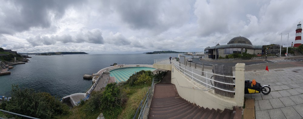
First up was the relatively small city of Plymouth (above), which took ages to get across, despite apparently having loads of cycle routes. As is depressingly usual in the UK, spotty bits of randomly-disappearing (and / or poor-quality, badly-signposted) bike infrastructure are the problem. It’s not specifically Plymouth’s fault; it’s a general urban UK issue. But having to stop 10+ times to map-check when crossing a city centre is clearly not going to encourage more cycling.

Plymouth Hoe, where the picture was taken, is where Francis Drake was allegedly playing bowls when the Spanish Armada was sighted. It’s just as well he didn’t have to get to his ship on a bike, or the UK would by now have a long tradition of afternoon siestas.

You can probably see that the clouds were threatening already. Once finally free of Plymouth, I’ve felt like I’ve been stalked by heavy showers ever since, although they didn’t properly catch up with me until yesterday, as I fled eastwards.

20200724 1 Edit

I had a bit of deja-vu while lumping up and down the hills after Plymouth; there was a long-ish stretch where I was following exactly the same route along the fringes of Dartmoor as I did in 2015 (on the Scilly to Shetland ride). And it was drizzling a little, just like it was back then. Soon enough, though, it was time to peel off back towards the coast (above), and the Starcross Ferry across the river Exe estuary.

You might well expect a ferry which is heavily used by cyclists to avoid a detour around the estuary to be easy to access for touring cyclists? Well the crew on the boat were all great, and dealt with the large number of bikes (plus one idiot with a trailer) excellently. But… to access the western side of the crossing, you need to carry your bike (and trailer, or bags, or anything else heavy and bulky you have) up about forty steps, over a railway footbridge, and back down again – beware if you’re running a heavy touring rig!

20200724 3 Edit

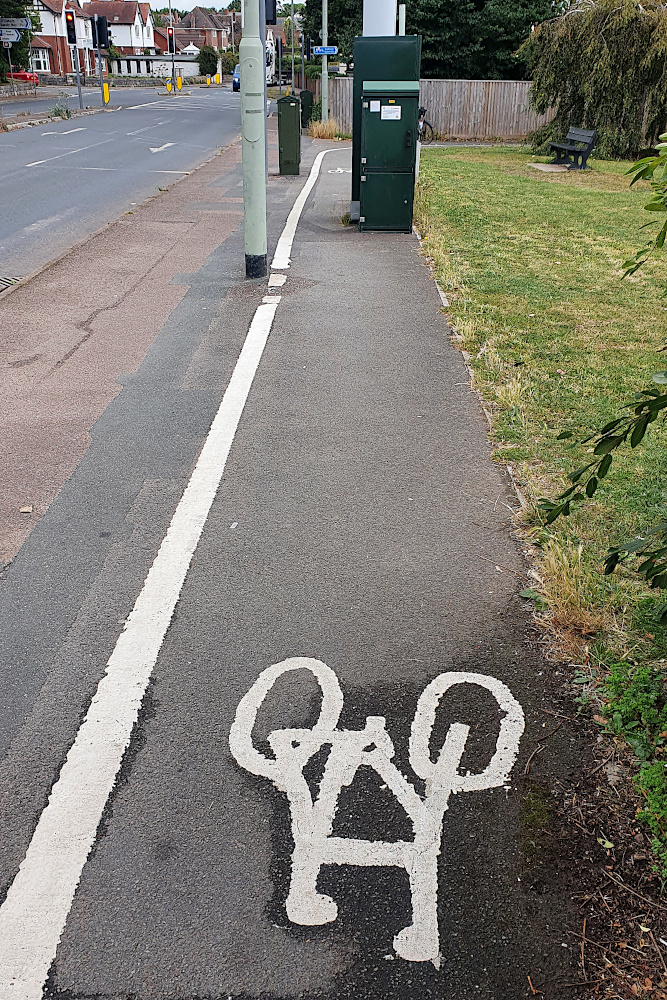
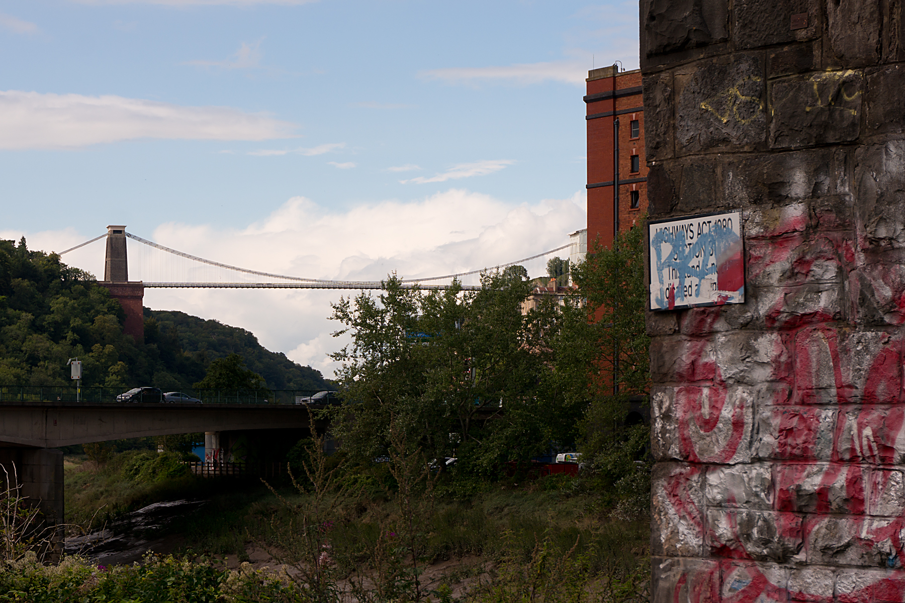
Once across the Exe, you’re in Exmouth. It’s a fairly small town, and seems pleasant enough, but is plagued with some of the same cycling issues as Plymouth. On the road out of the centre to rendezvous with a nice bike track on a disused railway, I suddenly noticed a brand new, wide shared bike and pedestrian path right next to me. I had no clue where it began, as I’d seen no signs, and I couldn’t get on it, as there was no access from the road. Grrr!! And when, just a few minutes later, I came across the astonishing piece of ‘infrastructure’ pictured above, I had to actually laugh at it.

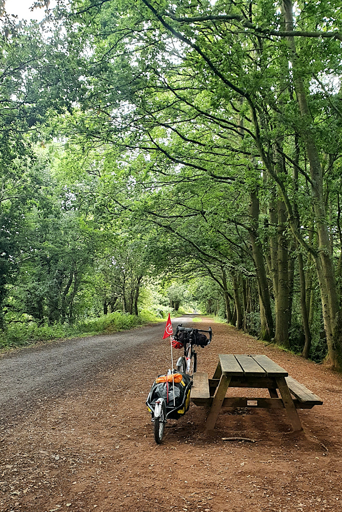
The abomination above actually comes between two sections of a traffic-free railway path, which is actually very nice (see below). But between them, the two pictures encapsulate the problem with UK cycling infrastructure; it’s good to ride anywhere where there are no cars. But if you’re anywhere near a road, expect cycling to be a time consuming 2nd class hassle, unless you’re willing to play with the traffic on the main roads.

20200724 4 Edit

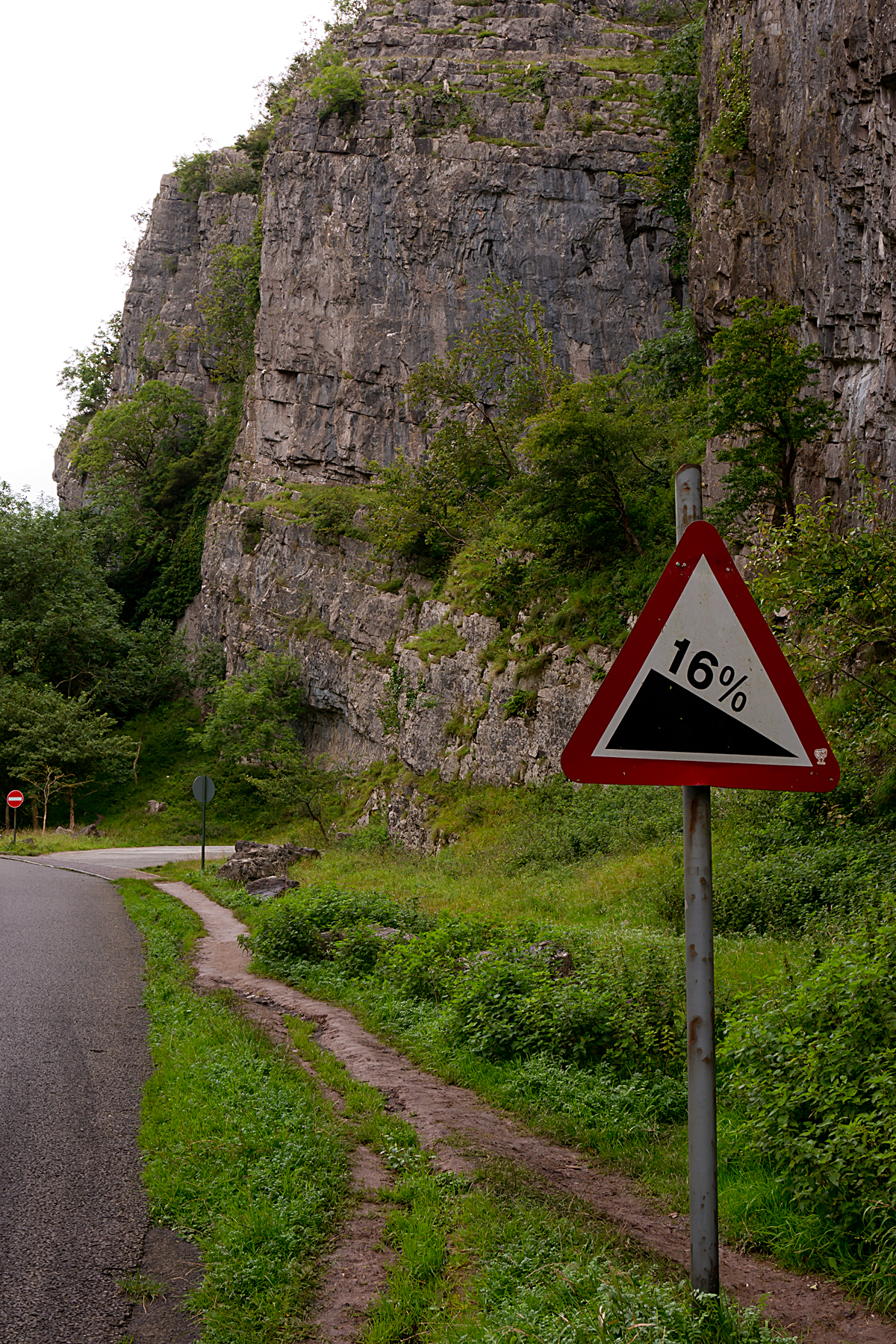
Phew. Think that’s rant over on the infrastructure. Devon’s other time-bending tool is the hills. I’ve got one more big set to go today, as I (hopefully) shoot eastwards. They do hurt (especially when they start at 8%, and just get steeper and steeper before maxing out at 20% ish, like the one below). And they’re not that quick on the way down, either, as the trailer needs a little bit of management at higher speeds.

20200724 5 Edit

But, although they slow you down, the hills do give you some lovely views of the countryside, which has been pretty throughout. There have been thatched villages and rolling farmland, and a full-on Fawlty Towers guesthouse experience in Torquay. Devon’s been pretty good in general.

Having avoided the first wet day of the trip by having a rest yesterday, it’s back on the road today into Dorset. There’s another, bigger, storm coming in tomorrow, so it looks like the first phase of the flatter run along the south coast may be a little disrupted.

On the plus side, the rain is rolling in on rapid tailwinds at the moment, so it could be that the time-bending can continue, and surprising amounts of progress can be made. Who knows?

Advertisement

The Covid Tour 2020

March 17th 2020. It’s St Patrick’s Day, but the pubs are quiet. A British Airways flight fails to take off from Heathrow airport en route to Buenos Aires. And fails to fly me out to start another big ride.

South America had been bugging me since I went straight from the US to New Zealand in 2014, instead of heading south. I’ve still never been, and was really looking forward to finally getting back on the intercontinental road, heading north on a bike from Ushuaia for as long as the money lasted.

The cash had been gathered, the flight booked, the bike built from the spokes up, and a trailer acquired to better deal with the long sections of gravel roads. I hadn’t actually packed, because there were already rumblings that the pandemic was about to ruin my plans. But leaving drinks had been drunk. And then, two hours after the drinks finished, Argentina closed its borders due to coronavirus. Followed by pretty much everyone else. South America would have to wait. Indefinitely.

20200714 Trip 1

With a degree of understatement, I’d have to admit that was all a little frustrating. On the other hand, given what’s been going on around the world since March, it could also have been a lot worse…

July 14th 2020. Covid World. The UK-wide lockdown is currently being lifted gradually and patchily. Most of the nation’s yearly quota of decent weather has already been used up. The Colston statue has been dunked and removed from Bristol harbour. And we’re on the brink of the biggest recession since I was a kid (or maybe bigger than that – who knows?). So it seems like the perfect time (really?!?) to take the bike, the kit and the frustration out on the road. Wales just half-opened its campsites, England’s pubs have been back for a couple of weeks with no obvious disasters (yet). Scotland are doing their own thing, and Northern Ireland too.

So let’s see if it’s still possible / sensible / advisable to lap the UK on a bike in 2020. Whether local lockdowns, or Scottish quarantines, or track and trace will scupper things. And if my legs have still got anything left in them (as seems to happen constantly, there are a few more miles on the clock than the last time I put thousands of kms together in a row).

20200716 Trip 5

There will be maps and so on later. I’m already late on the first post, as I’ve just woken up on Day 5, which should see me into Cornwall, providing I can dodge the tractors for a few more miles. So this is just a brief catch-up for now, until I can get enough electricity and time to do a proper job.

I’m heading anti-clockwise from Bristol. I wanted to go clockwise, kicking off with Wales, but the various Covid unlocking speeds have dictated the anti-clockwise circuit. It’s going to be something like 6000-ish km (4000-ish miles), assuming that neither the country, bike, the cash, or myself have a massive breakdown before that. And it’ll take in all four of the UK’s current constituent pieces. It should be interesting. But there are an awful lot of variables and potential things to go wrong…

20200716 Trip 7

The anticlockwise circuit is painful from the outset. As most people who’ve ridden long distances in the UK will know, the South West of England is pretty much the hardest bit. You can avoid hills everywhere else, or at least find a road with a sensible gradient. In the South West, it’s a constant battle with 10%+ gradients. And if you want to avoid them, you get 20%, or 25% instead. These are pretty inhuman gradients on a carbon road bike, let alone on a three-wheeled, 40kg touring rig. I wanted to get plenty of miles in my legs before facing this lot. Instead, it’s been pretty brutal from day two onwards so far.

On the other hand, the weather’s been decent until now, the views are spectacular, and there have been some nice breaks from the pain of winching uphill. As I pedalled up the Tarka Trail, an old railway line heading inland from Barnstaple yesterday, the sun was out, the route was flat for a few miles, and I remembered why I got into this bike touring lark in the first place.

20200717 Trip 11

I’m behind schedule (of course), and it seems to have rained twelve hours early this morning, so the weather’s back to standard English unpredictability. Cornwall is only a few miles down the road, so I’d best get cracking. More to come soon, hopefully!

By the way, I’ve spent a lot of time at The Bristol Bike Project since I got home in 2016. Times are tough for many social enterprises and charities at the moment, but please have a look at their website, and consider dropping them a few quid at a difficult time if you can.

Touring the UK – Map and Stats

After hurtling (relatively speaking) back to Bristol from the top of Shetland in a mere 30 hours, by bike, ferry, train, and bike again, I’ve had a few days off to relax.

And now’s the chance to get a bit of reflection in on the UK tour, before planning begins in earnest for resuming the round-the-world trip in a couple of months (that’s looking like early December now, by the way).  From the Isles of Scilly to Shetland, it was a fair ride, with loads to think about along the way.

20150904RTW_1

I’ll put up a full post-mortem on what went well, what I’d have done differently, and so on, fairly shortly.  It’s also just possible that I’ll finally get around to updating the rest of the pages here to more accurately reflect what’s actually been going on for the last six months or so.

But for now, this is just the bare-bones summary (via a map and some statistics) of my little tour of the length of the UK.

MAP:

Hopefully, the Google maps gremlins of a few weeks ago have given themselves some time off.  This should show the route I took.  The markers show mainly overnight stops, with a few extras to clarify direction or ferry ports etc.

If Google (or even I) have once again failed to deliver any useful information on the map, you’ll just have to imagine it.

And every map needs some statistics to go with it.

STATS:

NB – these are all Bristol to Bristol (i.e. including travel to and from the start and finish of the ride).

Measurements:

Total Cycling Distance – 1814 km / 1127 miles
Total Ascent – 11231 m / 36838 ft (1.27 times the height of Mount Everest)
Overall Toughness Index – 61.91 (100 = Really Tough with bags on)
Toughest Area – Devon and Cornwall (SW England) – Average TI 85.66

Days:

Total Days (Bristol to Bristol) – 28
Full Riding Days – 19
Average Full Riding Day Mileage – 90 km / 56 miles
Rest, Short Ride and Travel Days – 9
Wet days – 2 (which is really quite remarkable for the UK)

20150907RTW_18

Geography and Transport:

Countries Ridden – 1 – the United Kingdom.  Or:
Countries Ridden – 4 – England, Wales, Northern Ireland, Scotland.  And:
British Crown Dependencies Ridden – 1 – Isle of Man
Islands Ridden – 11 – St Mary’s, Great Britain, Isle of Man, Ireland, South Ronaldsay / Burray, Glims Holm, Lamb Holm, Mainland (Orkney), Mainland (Shetland), Yell, Unst
Ferries – 12
Approximate Hours on Ferries – 28
Trains – 2
Approximate Hours on Trains – 14 (a tad longer than flying from London to Singapore)

IMG_0524

Diversity:

Issuers of UK pound-denominated banknotes spotted – 7 – Bank of England, Isle of Man Government, Bank of Ireland, Ulster Bank, Clydesdale Bank, Bank of Scotland, Royal Bank of Scotland (I missed out on the full set; First Trust, and Danske Bank notes – bizarrely, the Danes can apparently print pounds – eluded me in Northern Ireland)

Indigenous Languages Encountered – 6 to 9, depending on what’s a language and what’s a dialect – English, Cornish, Welsh, Manx, Irish Gaelic, Scots, Scots Gaelic, Orcadian, Shetlandic (Orcadian and Shetlandic are basically Scots mixed with Norn, an extinct Norse language)

IMG_0552

Miscellaneous:

Unfortunate Encounters with Trucks – 0
Near Misses with Traffic – 0
General Traffic Behaviour – Good
Dreadful road surfaces – Several, but Ayr (and the towns around it) stood out as actively dangerous to cyclists
Near-Catastrophic Skids due to Sheep Droppings – 1
Canine Confrontations – 1 (not serious)
Illness – just the explosive fish incident in Cornwall
Punctures – 0
Mechanical Problems – 0
Days cut short due to pain / discomfort from Thai accident damage – 1
Ibuprofen capsules taken – 32
Memorials to Russian Warships passed – 1 (and, yes, that’s specifically a memorial for the ship, not the people on it)

IMG_0527

Well, that’s the outline.  As I said above, I’ll post some more detailed thoughts on the ride later.  Those are likely to be fairly positive, due to the lack of any major disasters.  For now, I’ll just point out my clear preference for surface transport over planes.  As I left the Shetlands on the overnight ferry to Aberdeen, I was reminded how getting on a boat to go overseas really feels like travelling.  Far preferable to getting in a little metal tube to pop effortlessly from one concrete-and-glass terminal to another.

20150923RTW_9

And the view’s a little better too…

Out of the West

UK Tour Stage 1:
Cycling Distance – 340km / 211 miles
Ascent – 2912m / 9551 ft (0.33 times the height of Mount Everest)
Toughness Index* – 85.66 (100 = a proper tough day)

UK Total Cycling Distance – 340km / 211 miles
UK Total Ascent – 2912m / 9551 ft (0.33 Everests)

Well, that hurt a bit more than I expected.

I’d intended to write a post between the start and today’s (Wednesday’s) first rest day.  But when the time came, I was exhausted enough to nod off while thinking about what to write, and it didn’t quite happen.

So there’s a lot of ground to cover; the whole of stage one of my ride up the country.  All the way from the Isles of Scilly up to Bristol.  Sunshine and rain; hills and, erm, more hills; sweat and vomit.  It’s all here.  But we’d better start at the start.  At the very end of the UK.

20150830RTW_5
The Isles of Scilly are 30-odd miles into the Atlantic Ocean, south-west of the tip of Cornwall.  St Agnes, which you can see in the background of the photo above, is the southernmost inhabited place in the UK.  Despite being stuck out in the ocean, the Scillies seem to benefit from a microclimate, and were noticeably warmer than the rest of the country.  I had a little pootle around the main island, St Mary’s, partly to get used to riding with bags on again, and partly to calm the Beastlet, which was understandably traumatised after being consigned to a container for the trip over.

20150830RTW_11
A sit down overlooking the bay at Hugh Town (above), and a pint in (roughly) the third most southerly pub in the country, and my time on the islands was up.  The grumbling bike was containerised again, and it was back to the mainland on Friday evening.  The proper riding would begin the next morning.

I was up early, encouraged by my early success in putting my tent up in the dark the night before, and was on my way before eight.  There are few better places to wake up than next door to St Michael’s Mount at the eastern end of the bay at Penzance:

20150830RTW_25
Tanked up on greasy food and coffee (as any sports nutritionist will tell you, it’s the only way to prepare for a long bike ride), it was time to move.  The north awaited (well, everything’s north from here).  And the hills.

20150830RTW_38
Pretty soon, Cornwall was teaching me lessons.

Lesson 1 was that, if you want to avoid the main roads in the south west (which you probably do, as they’re basically 70 mph motorways full of trucks and caravans), you’re going to be punished by climbing hills.  The smaller roads in Cornwall link the towns together, and pretty much every town seems to be on top of a vicious little slope (or at the bottom of a steep valley, which you need to climb out of).  I’d later discover that in Devon, they don’t even bother to put towns on top of the hills; the roads just go there anyway.  These small roads are nice and (fairly) quiet, and the countryside is lovely, but you’re not going to be setting any speed records in this part of the world.

20150830RTW_32
Lesson 2 taught me that, despite my earlier statements about being fit enough to get back to touring, my back’s still struggling a bit.  Not so much with the cycling, but just with being up and about all day, bending and stretching, without the option of three or four hours in a comfy seat.  I’m hoping that the rest day today will give it a chance to recover, and that things will get easier.  We’ll see, I guess.

Third, I’ve learned to avoid fish while I’m riding.  That’s eating fish, obviously; it’s relatively easy to avoid running them over on the road.  Top protein source that it is, fish has a greater chance than most food of, erm, going a bit wrong on you.  And, as any sports nutritionist really will tell you, the explosive loss of half a day’s carbs and protein is not a good way to set yourself up for another day in the saddle.  Sadly, that’s exactly what happened on Saturday night, and I wobbled across the border into Devon on Sunday afternoon, running on fumes.

20150830RTW_37
Leaving Cornwall, you get another reminder of the impact of the great Victorian engineer, IK Brunel, on the infrastructure of the south west.  I’ve gone on about Big Isambard before while trundling around Bristol, so I won’t overdo it this time.  But his railway bridge across the Tamar marks the end of Cornwall, and the beginning of England proper (Cornwall, or Kernow, is a little bit different from the rest of England, with its own Celtic language, which you might have noticed on the picture near the top of the post, and its own flag, which you see on a lot of cars and houses; some people there think it should be a separate country).

Devon turned out to be a struggle.  Having limped out of Cornwall, I assumed that a good feed and a decent night’s sleep would sort me out.  I also assumed that the rolling Devon countryside would be a little kinder than Cornwall’s rocky outcrops.  In fact, Monday was spent slogging up and down more hills.  A lot more hills.  My depleted energy levels made themselves felt again, and I finally rolled into Exeter absolutely stuffed.

20150831RTW_11
I had a sit down next to the fine cathedral, and pondered the facts.  I had no energy left.  And while that would have been fine at the end of the day’s ride, I wasn’t at the end of the day’s ride.  I’d like to claim that I agonised over this for hours, but I really didn’t.  I got on the train for the last few miles to Taunton.  And spent the evening wondering whether I could actually make this trip work (or, at least, whether I needed to double the amount of time it’s going to take).

But yesterday (Tuesday) was another day in every way.  The sun was out.  A proper sleep and feed seemed to have sorted me out.  Or maybe it was just the psychological aspect; knowing you’re heading home for a rest day definitely makes things easier.

20150901RTW_5
It also helped that the first half of the day was across the Somerset Levels.  As you may have inferred, the area has that name because it’s flat.  Or at least mainly flat.  There are a couple of ridges and artificial hills, but it’s flat enough that the tower of Glastonbury Tor sticks out from miles away (above).  In any case, it was pleasant, and relatively easy riding to lunch at Cheddar.

While Glastonbury is famous for the music festival, the little town of Cheddar should also be globally famous; after all, you can buy ‘Cheddar’ cheese pretty much anywhere in the world.  Unfortunately, the region was too late in protecting the name, so its rightful place as the home of the world’s finest cheese has been a little lost, usurped by plastic ‘cheddar’ in plastic pouches.  How very sad…

Cheese-related rants aside, Cheddar does have another string to its bow; the Cheddar Gorge.  I could have looked for a flatter route to Bristol, wiggling around the Mendip Hills, rather than pushing straight over, but the Gorge is a special climb, which I really wanted to ride.  There are a bunch more pictures and a review of the climb here.  Not wimping out of it definitely shows how much better I was feeling.

20150901RTW_11
After fortification with chips and sugary drinks, it was time to hit the climb.  The steeper section is about 150 vertical metres, but it’s over 200 all the way to the top.  Which is not massive by world standards, but it is a decent little hill.  And, despite the 16% gradient, the Beastlet and I did OK.  There were even enough tourists around to give encouragement (once they’d finished laughing at the number of bags I was lugging up the hill), which was nice.  And because the really steep bit is relatively early on the climb, the top section, which is somewhere around 4-5%, feels more-or-less flat.  I’m putting it down as the first loaded climb which I actually enjoyed on this trip.

Once over the Gorge, I was nearly on home turf.  Another big lump over Dundry, and then the drop into Bristol (complete with Brunel’s – again! – iconic Clifton Suspension Bridge, below).  Past Ashton Gate, along the edge of the floating harbour, and up the familiar railway track.  Home in time for tea.  And that well-deserved day off.

20150901RTW_14
How it goes from here is going to be largely determined by how well the back recovers; if yesterday’s anything to go by, things should be OK.  There’s even a rumour that August’s awful weather may be replaced by a drier spell, at least for a few days.

And so, tomorrow (Thursday) it’s off to Wales.  My second country of the UK.  Another language.  More hills.  But definitely no more fish.

*The Toughness Index (TI) was developed in New Zealand, in 2014, after a conversation with fellow loaded tourer (and hill climb obsessive) Ben Greeve.  It gives you an idea of how hard the riding is on any given section.  TI 100 is a benchmark ‘Tough’ day on a fully loaded (say 35-45kg) touring rig.  TI 100 is equivalent to climbing 1000 vertical metres per 100km (roughly 3280ft per 62 miles).  A lot of the riding in New Zealand’s South Island comes out around TI 100.  For comparison, crossing the Great Divide in the Rockies took me over Wolf Creek Pass, and down the other side.  That 98km / 61 mile day had a TI of 90.1.