south

Unpredictable Watery Ways

The UK is an archipelago of hundreds of islands, which means that the water between is always important.

It was the only way to get around for centuries, avoiding hostile terrain, tribes and bears. Especially in the more northern parts, and where the shoreline has been splintered by the Atlantic. But, though travelling by boat used to be the most reliable way to get around the islands in the west of the UK, that’s not necessarily the case in 2020.

20200829 4 Edit

Saturday was an unexpected little bonus. I’d planned to be on an early morning ferry out of the Hebrides to Mallaig on the mainland. I hadn’t factored in the local stock sales, which are apparently important enough to completely change the boat schedules. The good side of this was that it was now an evening sailing, which gave me a chance for a short trip to Eriskay (above) before I left the islands, which was nice.

The better side was that the sales apparently went very well for the locals, and I was plied with some top quality, free whisky while waiting for the boat in the evening. By farmers, who are not exactly well known for their largesse.

20200829 8 Edit

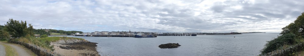
The downside was that the ferry was now taking me to Oban, further south than Mallaig, and cutting two spectacular riding days off the trip. It was also dark, meaning that my view of the Ardnamurchan Peninsular (above) was a little restricted. A shame, as that’s the westernmost part of Great Britain, which I’d been hoping to have a proper look at.

20200830 1 Edit

Still, the next morning I was back on the bike on the mainland. The sudden transition from the windswept, almost treeless islands to the lusher, more heavily-forested mainland was a little bit shocking. There were actually palm trees in the centre of Oban!

20200830 2 Edit

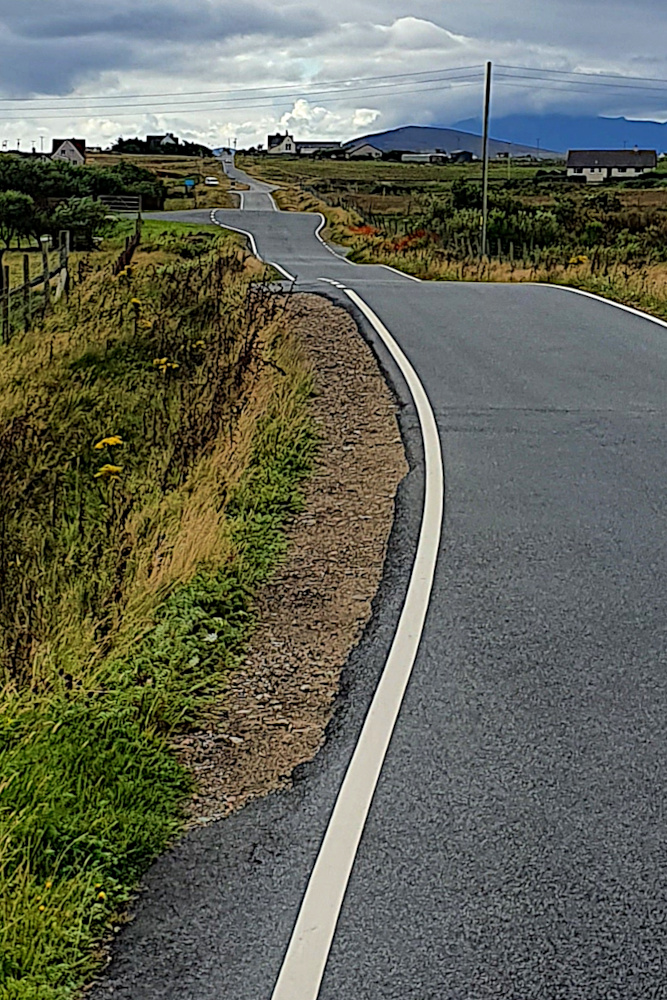
Once I’d got over the shock of swapping one micro-climate for another, I had a lovely day’s ride along the brilliantly-named Loch Awe. It’s worth noting, if you’re ever intending to do the same, that the map makes it looks like a road right by the loch side, which must be pretty flat. It really isn’t like that (above). But it was nice and quiet, and very pretty.

20200830 6 Edit

Loch Awe drops you off close to the Crinan Canal (above), which again shows the importance of water around here. It was dug to save huge amounts of time for boats coming out of Glasgow and heading for the west coast and islands. Being Scotland, it’s now got a rather lovely shared-use path along it. The canal essentially removed the need to go around the Kintyre Peninsular, which is a long finger of land, extending south to within a few miles of Northern Ireland.

20200831 1 Edit

This time it was Covid messing the boats up. There’s normally a small ferry from the tip of Kintyre to the Antrim Coast. But that’s been shut down this year. With the Isle of Man also out-of-bounds due to Covid restrictions, my only option to get to Northern Ireland is via Cairnryan, way to the south. So, while I started off yesterday down the Kintyre Peninsular (above), this was only with the aim of hopping onto the Isle of Arran…

20200831 10 Edit

…before hopping straight off again. The island is often described as Scotland in miniature, although the pass I had to ride over straight off the boat didn’t feel especially small. But using the island as a stepping stone between two ferries which were working as expected (hooray!) has worked a treat.

I’ve now just got a long run down the Ayrshire / Galloway coast to reach Cairnryan, and a boat to Ireland. It’s probably time to rebalance the number of miles covered by bike with the number covered by ship. This isn’t a blog about British ferries (if such a thing exists), after all.

But I hope Northern Ireland will give me that chance in the next few days.  Assuming I can get there…

Atlantic Edge

Well, the last few days have been a bit of a rush. And it’s not quite over yet.

I’ve had tailwinds all the way from Thurso. On the most exposed section of the ride, where the ‘normal’ should be rain-laden headwinds. I think I’ve made the most of the unexpected assistance. At the same time, both Covid and non-Covid related disruption to transport and tourist accommodation have made their presence felt much more up here than elsewhere in the country.

20200827 2 Edit

I guess it helps you to appreciate that this area is properly remote, by European standards, at least. From the small town of Thurso, near John o’Groats, to the small town of Stornoway (above) in the Outer Hebrides, where I wrote the last post, it’s over 140miles (about 230 km) of riding, plus a 3-hour ferry ride. In between, there’s a handful of villages and some stunning countryside – see the pictures on the previous post. But not much else. Apart from sheep. There are lots of sheep.

As the last post hopefully showed, I made a lot of ground quite quickly out of Thurso, along a route which got steadily more beautiful as I got further west. A little rain, but not enough to ruin things. A few midges (some of the bites are still itching several days later), but not the massive bloodthirsty midge-storms you sometimes hear about up here.

It was all going fine until Ullapool, where I really needed a shower, and instead found everything closed (to tents at least). So, a quick switch of direction led me onto the ferry to the Hebrides. At least it meant I didn’t have to agonise too much over whether to head for the islands or stick with mainland Scotland…

20200827 3 Edit

And the Outer Hebrides have been good. Dramatic scenery, of mountains which have been partially smashed over millions of years by Atlantic storms. Improved further by a following wind, which has pushed me along very easily. There’s even a marked Hebridean Way cycle route from top to bottom (like all the other signs up here, in Gaelic first, English second).

20200828 11 Edit

The only downsides are that it’s a cold northerly wind, and the thermals and winter gloves are out already. In August! And that ‘everything’s closed’ is a phrase which has cropped up far too much in the last couple of days.

Thursday began in Stornoway, and was intended to be a relatively gentle meander through Lewis and Harris (confusingly, these act as if they’re are two separate islands, but they’re definitely joined together). The Lewis part went nicely, zipping south at a rapid rate (above and below), although there was definitely a lot more heavy cloud than the forecast – light cloud and sunny spells – had suggested.

20200827 7 Edit

Unfortunately, the weather forecast got even less accurate as the afternoon went on. Harris, I’d been assured by other cyclists, was stunning, with some beautiful wild camping near lovely beaches. I couldn’t see it myself. Literally – all I saw was raindrops on my glasses, and sheets of rain sweeping across the landscape.

I was soaked and being chilled by the northerly wind. Not a great combination. I headed for the ferry stop at Leverburgh, on the basis that I could probably find somewhere to warm up and dry off before camping. No such luck. Everything apart from the ferry itself was shut, and the last one of those was about to head to the next island, Berneray. I got on it.

20200828 3 Edit

Some frantic phone tapping on the boat revealed that there were no open accommodation options within range on the other side. The Covid effect again. So it would be wild camping. Which would be fine, except that I was already shivering, and the chances of drying off properly in a little tent were low. I ended up staking my claim to the ferry waiting room on the other side; no heating, but four walls and a toilet, so it actually worked out OK, and I was warm, dry and ready to go early the next morning (onto North Uist – above).

20200828 5 Edit

And yesterday’s run down to the southern part of South Uist (via Benbecula – that’s a lot of islands already!) was lovely. The weather was what it should have been the day before, and I was jetting south along flat(ish) roads.

20200828 7 Edit

The biggest challenge along the Hebrides chain has been the single-track main roads (above). These are ‘A’ Roads, so you’d expect them to be high-volume, fast routes, possibly dual-carriageways. Things are different up here. There are some sections that have white lines down the middle, but also long stretches where you have to dart between passing places. I guess it’s another function of how remote and unpopulated this region is. But it makes for a really strange riding rhythm; sprinting and stopping all day, instead of a steady effort.

20200828 12 Edit

Anyway, I rolled down to close to Lochboisdale yesterday, in preparation for this morning’s early ferry to Mallaig, back on the mainland, and one end of what’s now known as the ‘Harry Potter Railway’.

But, in case it wasn’t already clear enough that I’m not on the mainland yet, there’s a cattle market on somewhere (I’m still not clear exactly where this is). This means that the Mallaig ferries are all cancelled. It would, perhaps, have been useful to know this before I charged the length of the Outer Hebrides, and possibly before I even got on the boat to Stornoway.

Thankfully, there is one ferry off South Uist before Monday, and that’s going late this evening (Saturday). I’ll be on it. But it’s not going to Mallaig, but to Oban (quite a lot further south, and chopping a couple of days off the ride). So I’ll miss Harry Potter. Hopefully, this won’t ruin my life too much, and things will become a bit more predictable and controlled when I’m back on the mainland, but we’ll have to wait and see…